EGCL conducts remote sensing research that addresses the intersection of environmental niche and agricultural system decisions, transforming scientific data into actionable knowledge through maps and spatial analysis.
Current Research
Crop suitability across temporal scales
Dr. Brad G. Peter, Lead Investigator (2022–Present)
Funding: University of Arkansas
Prior support from USAID
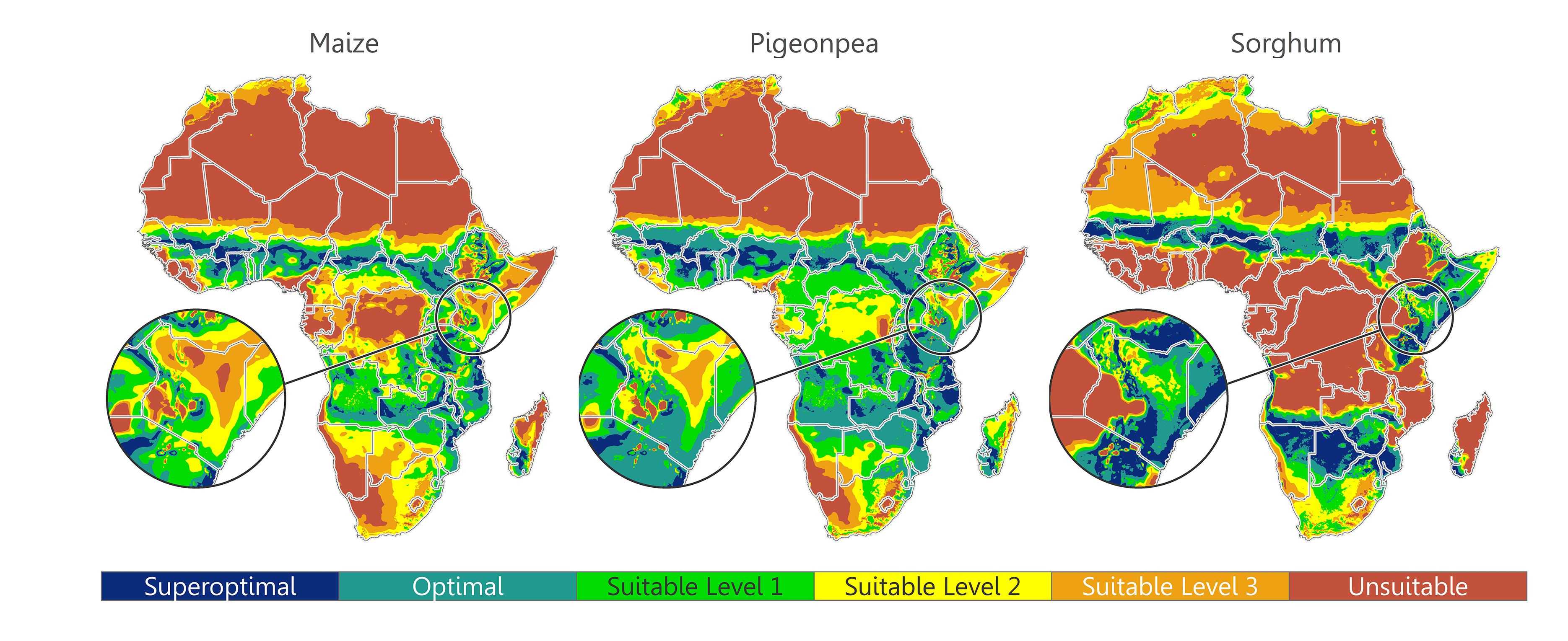
Abstract. “Climate change, food security, and environmental sustainability are pressing issues faced by today’s global population. As production demands increase and climate threatens crop productivity, agricultural research develops innovative technologies to meet these challenges. Strategies include biodiverse cropping arrangements, new crop introductions, and genetic modification of crop varieties that are resilient to climatic and environmental stressors. Geography in particular is equipped to address a critical question in this pursuit—when and where can crop system innovations be introduced? This manuscript presents a case study of the geographic scaling potential utilizing common bean, delivers an open access Google Earth Engine geovisualization application for mapping the fundamental climate niche of any crop, and discusses food security and legume biodiversity in Sub-Saharan Africa. The application is temporally agile, allowing variable growing season selections and the production of ‘living maps’ that are continually producible as new data become available. This is an essential communication tool for the future, as practitioners can evaluate the potential geographic range for newly-developed, experimental, and underrepresented crop varieties for facilitating sustainable and innovative agroecological solutions.”
Peter, B. G., Messina, J. P., Lin, Z., and Snapp, S. S. 2020. Crop climate suitability mapping on the cloud: A geovisualization application for sustainable agriculture. Scientific Reports 10(15487). doi: 10.1038/s41598-020-72384-x
Peter, B. G., Messina, J. P., Lin, Z., and Snapp, S. S. 2020. Crop climate suitability mapping on the cloud: A geovisualization application for sustainable agriculture. Scientific Reports 10(15487). doi: 10.1038/s41598-020-72384-x
Divergent local responses to globalization: Urbanization, land transition, and environmental changes in Southeast Asia
Dr. Brad G. Peter, Researcher (2020–Present)
PIs: Dr. Peilei Fan (Michigan State University) and Joseph Messina (Co-PI; University of Alabama); http://seagul.info/
Funding: NASA Land-Cover and Land-Use Change Program
“Southeast Asia, a vast area of 4.5 million sq km with more than 641 million people, experienced rapid urbanization, doubling the urbanization ratio from 24% in 1976 to 48% in 2016, with several cities doubling urban built-up land in just two decades (HCMC, Hanoi, and Yangon from 1990 to 2010) coincident with severe degradation of the urban environment. Globalization has been recognized as one of the most significant driving forces of land transitions in Southeast Asia. It includes flows of commodity (international trade), capital (foreign direct investment (FDI)), money (remittance and overseas aid), and people (rural-urban migration, and international workers, and tourists). Our objective is to examine how diverse local responses to globalization affected land transitions, particularly urbanization, and urban environmental changes across 7 SEA countries, i.e., Cambodia, Indonesia, Lao PDR, Myanmar, Philippines, Thailand, and Vietnam and 12 case cities, with 3 particular tasks of data processing and hypothesis testing: Task 1. Urban land transition and its relationship to other land transitions; Task 2. Urban environmental changes (air pollution) patterns, drivers, and impacts; Task 3. Divergent local responses to globalization.”
Peter, B. G., Messina, J. P., Kapoor, A., Fung., C., Breeze, V., and Fan, P. [in review] Modifiable spatiotemporal unit problems in remote sensing of agriculture: Evidence from rice production in Vietnam.
Land-use/land-cover change in Southeast Asia countries from 1961 to 2016
This ‘bar chart race’ shows the change in agricultural land (as a percent of the total land area) in Southeast Asia countries from 1961 to 2016. Countries depicted in orange are part of the SEAGUL research project. Data: WorldBank | Agricultural land (% of land area)
Past Research
WaterServ: A Cyberinfrastructure for Analysis, Visualization and Sharing of Hydrological Data
Dr. Brad G. Peter, Co-PI, Postdoctoral Researcher
PI: Dr. Sagy Cohen (University of Alabama); https://waterserv.ua.edu/
Funding: University of Alabama CyberSeed Grant
“Accessibility to hydrological measurements, model predictions and Earth observing imagery has never been greater. This has led to rapid acceleration in the development, by government and international agencies, private companies, and academic researchers, of new systems for predicting and analyzing extreme hydrological events (floods and droughts). Examples include the NOAA National Water Center (NWC) National Water Model (NWM), the European Union Joint Research Center (JRC) Global Flood Awareness System (GloFAS), and Google flood forecasting system (under development). While these types of emerging systems are poised to greatly improve social resilience to flood and drought, their impact remains quite limited. This is mainly due to the disparity of their end-user access points and difficulties in utilizing their products.”
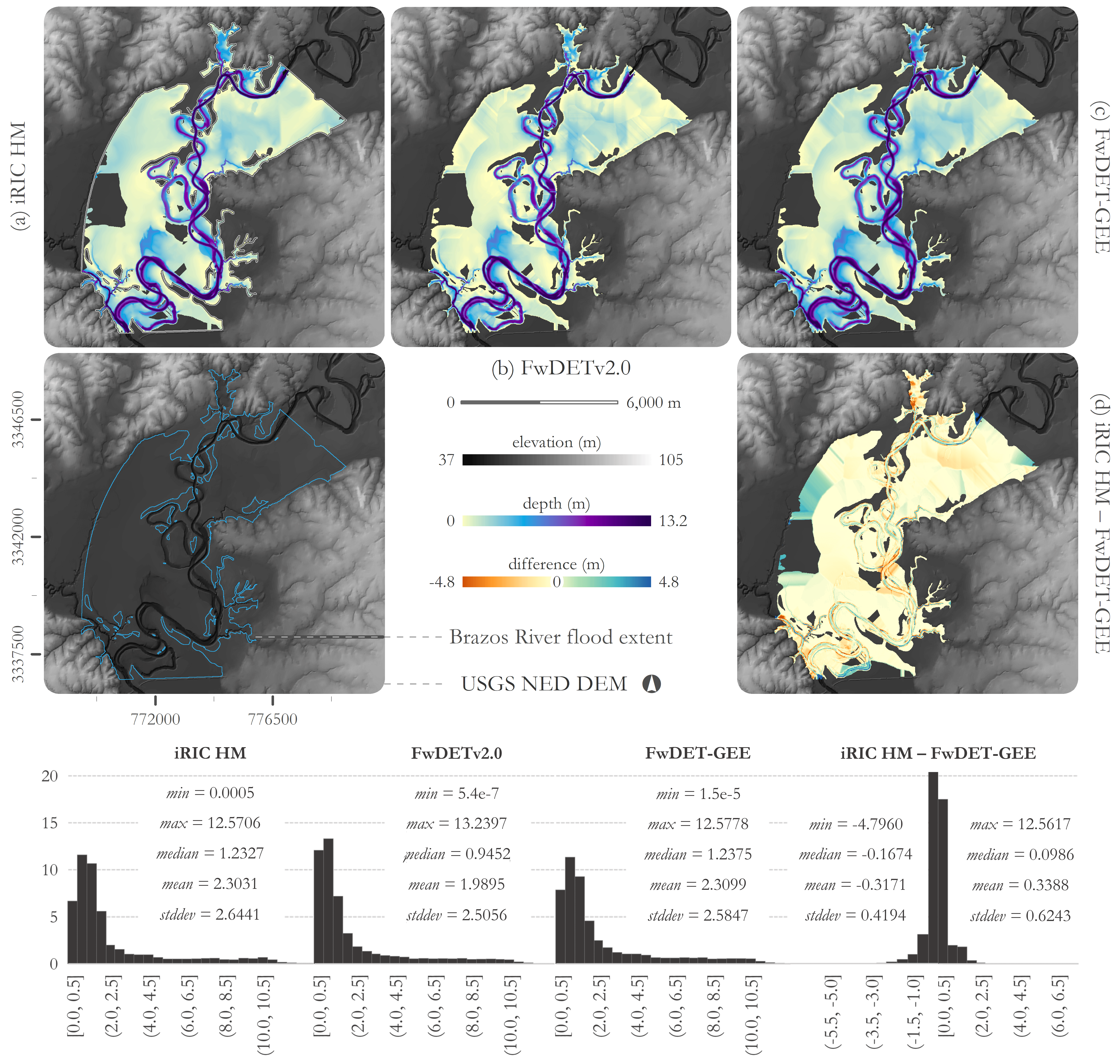
Peter, B. G., Cohen, S., Lucey, R., Munasinghe, D., Raney, A., and Brakenridge, G. R. 2020. Google Earth Engine Implementation of the Floodwater Depth Estimation Tool (FwDET-GEE) for Rapid and Large Scale Flood Analysis. IEEE Geoscience and Remote Sensing Letters 1–5. doi: 10.1109/LGRS.2020.3031190.
Precision agriculture for smallholder farming systems in Africa
B. Peter, Graduate Assistant Researcher
PI: Dr. Joseph Messina (Michigan State University); https://www.k-state.edu/siil/whatwedo/pastprojects/malawi/index.html
Funding: USAID Feed the Future
“The purpose of this project is to collect and integrate multi-scale data and analytic techniques to generate inter- and intra-seasonal decision support guidance capable of improving Malawian smallholder farmers’ agricultural productivity. Recent advances in data management and modeling and in the commercialization of remote sensing tools are leading to dramatic improvements in our understanding of the multi-scale spatial patterns of soils, weather and climate, and agricultural productivity. These types of data are now increasingly available in Africa to combine with farm survey data on farm management, input use, and soil characteristics to provide inter- and intra-seasonal decision support guidance for agricultural extension systems for the benefit of smallholder farmers. In essence, the project seeks to demonstrate how to make agriculture in developing countries ‘smarter’ through newly available tools for collecting and and analyzing large volumes of data on productivity, suitability, and producer behavior.”
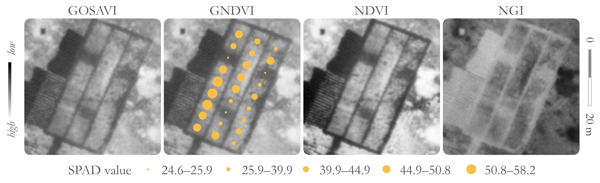
Peter, B. G., Messina, J. P., Carroll, J. W., and Chikowo, R. 2021. A case for green-based spectral indices: Plot-scale sUAS imagery related to crop chlorophyll content at two maize farms in Malawi. Remote Sensing Letters. doi: 10.1080/2150704X.2021.1938733.
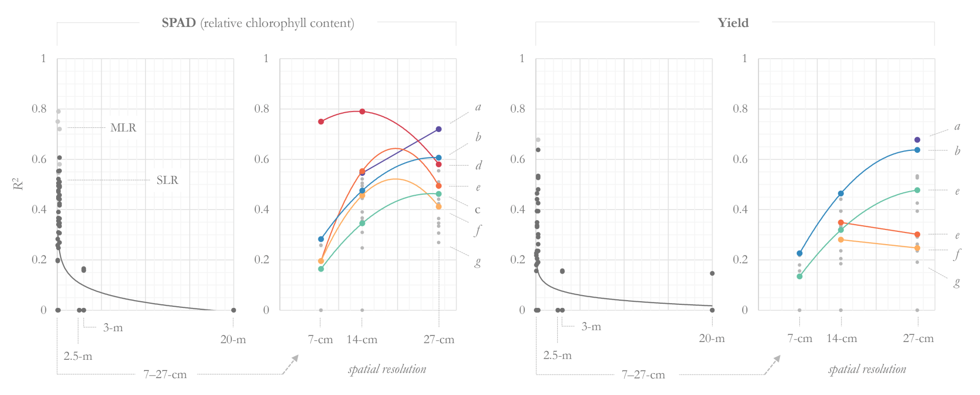
Peter, B. G., Messina, J. P., Carroll, J. W., Zhi, J., Chimonyo, V., Lin, S., and Snapp, S. S. 2020. Multi-spatial resolution satellite and sUAS imagery for precision agriculture on smallholder farms in Malawi. Photogrammetric Engineering & Remote Sensing (PE&RS) 86(2):107–119. doi: 10.14358/PERS.86.2.107.
Vector-borne disease and leveraging big data for public health
B. Peter, Researcher
PI: Dr. Joseph Messina (Michigan State University); https://www.k-state.edu/siil/whatwedo/pastprojects/malawi/index.html
Funding: USAID Feed the Future
PI: Dr. Edward D. Walker (Michigan State University); https://www.fic.nih.gov/News/Pages/2013-framework-innovation-awards.aspx
Funding: Fogarty International Center/NIH Framework Programs for Global Health Innovation
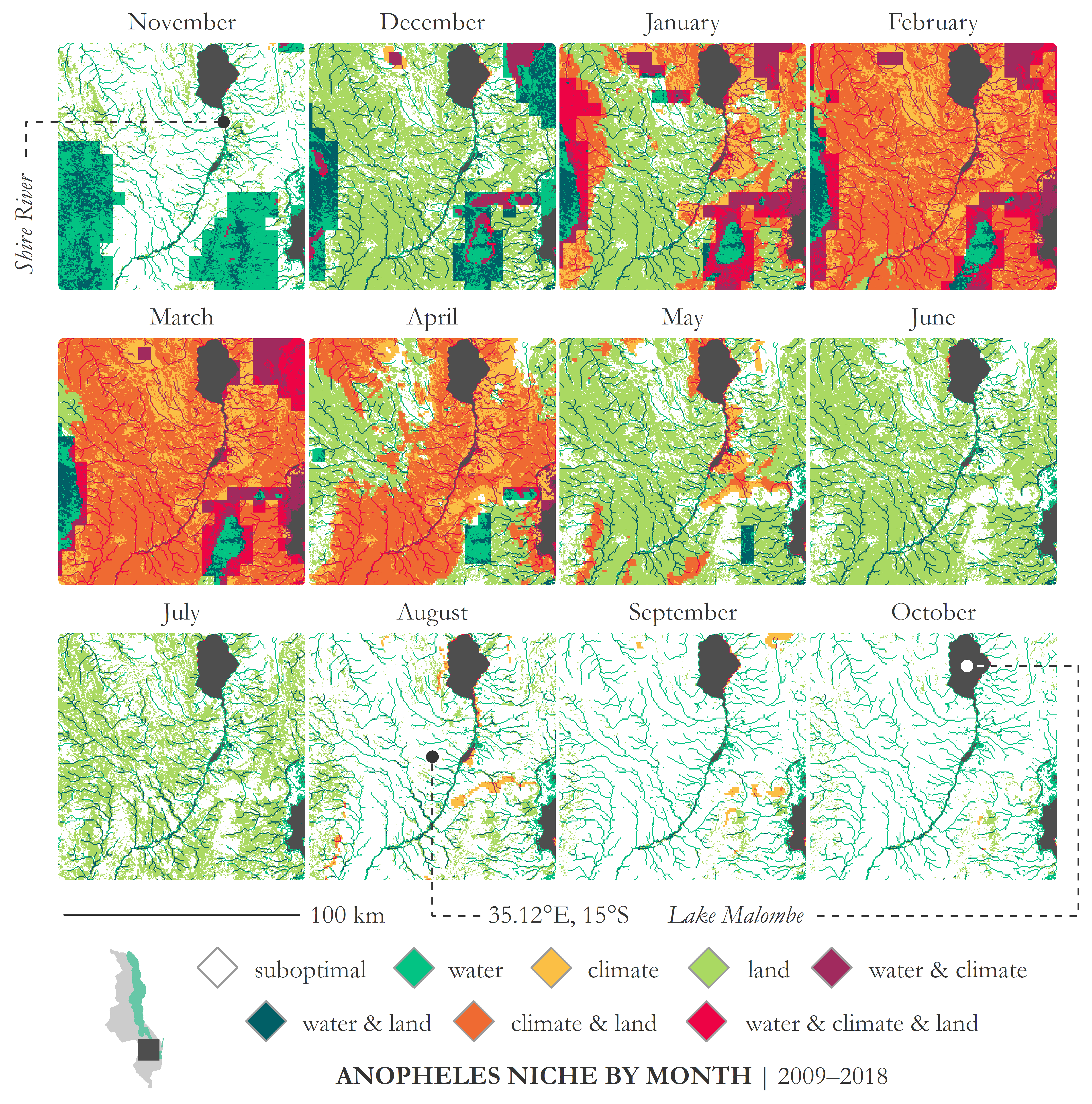
Abstract. “In an era of big data, the availability of satellite-derived global climate, terrain, and land cover imagery presents an opportunity for modeling the suitability of malaria disease vectors at fine spatial resolutions, across temporal scales, and over vast geographic extents. Leveraging cloud-based geospatial analytical tools, we present an environmental suitability model that considers water resources, flow accumulation areas, precipitation, temperature, vegetation, and land cover. In contrast to predictive models generated using spatially and temporally discontinuous mosquito presence information, this model provides continuous fine-spatial resolution information on the biophysical drivers of suitability. For the purposes of this study the model is parameterized for Anopheles gambiae s.s. in Malawi for the rainy (December–March) and dry seasons (April–November) in 2017; however, the model may be repurposed to accommodate different mosquito species, temporal periods, or geographical boundaries. Final products elucidate the drivers and potential habitat of Anopheles gambiae s.s. Rainy season results are presented by quartile of precipitation; Quartile four (Q4) identifies areas most likely to become inundated and shows 7.25% of Malawi exhibits suitable water conditions (water only) for Anopheles gambiae s.s., approximately 16% for water plus another factor, and 8.60% is maximally suitable, meeting suitability thresholds for water presence, terrain characteristics, and climatic conditions. Nearly 21% of Malawi is suitable for breeding based on land characteristics alone and 28.24% is suitable according to climate and land characteristics. Only 6.14% of the total land area is suboptimal. Dry season results show 25.07% of the total land area is suboptimal or unsuitable. Approximately 42% of Malawi is suitable based on land characteristics alone during the dry season, and 13.11% is suitable based on land plus another factor. Less than 2% meets suitability criteria for climate, water, and land criteria. Findings illustrate environmental drivers of suitability for malaria vectors, providing an opportunity for a more comprehensive approach to malaria control that includes not only modeled species distributions, but also the underlying drivers of suitability for a more effective approach to environmental management.”
Frake, A. N., Peter, B. G., Walker, E., and Messina, J. P. 2020. Leveraging big data for public health: Mapping malaria vector suitability in Malawi with Google Earth Engine. PLOS ONE 15(8): e0235697. doi: 10.1371/journal.pone.0235697
Frake, A. N., Peter, B. G., Walker, E., and Messina, J. P. 2020. Leveraging big data for public health: Mapping malaria vector suitability in Malawi with Google Earth Engine. PLOS ONE 15(8): e0235697. doi: 10.1371/journal.pone.0235697
Perennial grain crops for African smallholder farming systems
B. Peter, Graduate Assistant Researcher (2014–2018)
PI: Dr. Joseph Messina (Michigan State University); https://pgrainsforafrica.psm.msu.edu/
Funding: Bill & Melinda Gates Foundation
“Cultivation of perennial grain crops such as wheat, rice and sorghum, by smallholder African farmers potentially has many benefits, such as alleviation or reversal of soil degradation, increased soil health, reclamation of marginal land, and increased crop profitability. However, there has been little research devoted to the development of these crops for use in the tropics, particularly for marginal lands, and adoption by farmers may be difficult, especially without seeing immediate benefits and profits from soil conservation…One of the most common and most commonly overlooked development tasks is targeting. In this sense we are referring here to proactively determining the appropriate location and scaling potential for any development innovation. We faced three distinct problems with targeting and scaling perennial grains. 1) where is the agriculture, 2) where is a perennial grain innovation appropriate and scalable given biophysical constraints, current or future, and 3) how do we disentangle social factors driving poorly producing agricultural regions.”
Peter, B. G., Mungai, L., Messina, J., and Snapp, S. 2017. Nature-based agricultural solutions: Scaling perennial grains across Africa. Environmental Research 159:283–290. doi: 10.1016/j.envres.2017.08.011